Best Travel Window
October to December and March to May offer the best weather for Khaptad, Shuklaphanta, and hill routes. Monsoon months are greener but roads can be slower.
Capital: Godawari | Far-Western Region
The Western Frontier with Rich Cultural Heritage
A short visual overview before you explore geography, districts, and culture.
19,539 km² in far-western Nepal. Borders India to south/west and Tibet (China) to north. The name "Sudurpashchim" literally means "Far West" in Nepali, reflecting its geographic position at Nepal's western frontier.
Varied landscape from Himalayan peaks (Api - 7,132m, Saipal - 7,031m) to fertile Terai plains. The Mahakali River forms the western border with India. Contains Dadeldhura and Kailash mountain ranges with dramatic river valleys.
Subtropical in southern Terai (hot summers up to 42°C), temperate in mid-hills, and alpine in northern Himalayas (below freezing in winter). Drier than eastern Nepal with 1,000-1,500mm annual rainfall. Distinct monsoon season (June-September).
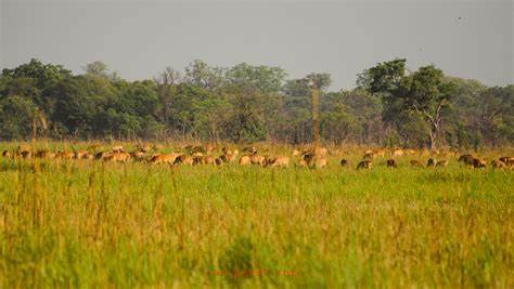
Home to Shuklaphanta National Park (305 km²), featuring the world's largest herd of swamp deer and significant tiger populations. The park contains the largest continuous grassland in Nepal alongside subtropical forests and wetlands.
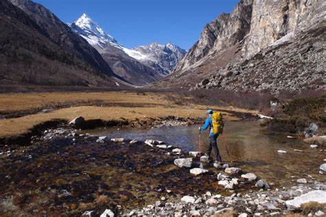
Remote mountainous district bordering India and China with the sacred Byas Valley (Byans Valley), unique Rang (Shauka) culture, and gateway to Api Himal and Kailash Mansarovar pilgrimage route.
Historical hill district featuring Amargadhi Fort, built during the unification of Nepal. Its strategic location offers panoramic views of the surrounding hills and, on clear days, the Indian plains.
Predominant group in the hills with distinct language, customs, and traditions. Known for preserving ancient Khas cultural practices and folklore that have largely disappeared elsewhere in Nepal.
Indigenous inhabitants of Terai regions in Kailali and Kanchanpur districts with unique Rana Tharu subgroup. Known for colorful attire, traditional Holi-ghar mud houses with artistic wall paintings, and rich folklore.
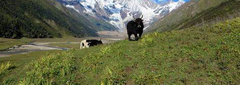
Rare Indo-Tibetan community in upper Darchula practicing transhumance (seasonal migration) with livestock. Known for unique cultural practices including the traditional "Jhura" marriage system and the "Chhanga" festival.
Main language of hill districts (approx. 45%), considered either a dialect of Nepali or separate language. Features distinct vocabulary and grammatical structures that preserve ancient forms of Khas language.
Official language (approx. 30%) used in education, administration, and inter-ethnic communication. Far-western dialect has unique expressions and accent.
Indigenous language (approx. 15%) spoken primarily in Terai districts, with the Rana Tharu dialect having significant differences from eastern Tharu variants.
Most significant festival of Sudurpashchim celebrating the marriage of Lord Shiva and Goddess Parvati over 8-10 days. Features unique rituals like Gavari (staying awake), Deuda dancing, and special songs with circular dance formations.
Spring festival celebrated on the full moon day of the month of Chaitra with ritual bathing in sacred rivers (especially Mahakali) and fasting. Known for cultural performances and community gatherings.
Important festival for Tharu communities marking the end of winter and beginning of agricultural year. Features distinctive rituals including house cleaning, feast preparation, and traditional Tharu dances.
Established in 1976 and covering 305 km², this less-visited national park offers authentic wildlife experiences without crowds. Famous for having the world's largest concentration of swamp deer (over 2,000) and significant tiger populations, with recent evidence of rhino migration from Bardiya.
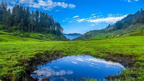
Unique high-altitude plateau (3,000m) covering 225 km² across four districts. Features 22 high-altitude lakes, over 300 species of medicinal herbs, and the ashram of sage Khaptad Baba. The vast meadows called "Patans" burst with wildflowers during spring and monsoon seasons.
Emerging trekking destination to the base of Api Himal (7,132m) in Darchula district. This off-the-beaten-path trek offers pristine mountain views, cultural encounters with Byasi (Rang) communities, and unspoiled alpine landscapes without the crowds of eastern Nepal trekking routes.
October to December and March to May offer the best weather for Khaptad, Shuklaphanta, and hill routes. Monsoon months are greener but roads can be slower.
Dhangadhi is the main entry hub for flights and highways. For mountain districts, leave generous travel buffers and confirm local transport one day in advance.
Pack both light and warm layers, plus rain cover in shoulder seasons. Cash and offline maps are practical must-haves outside major town centers.
Primary economic activity with subsistence farming in hills (millet, barley, wheat) and commercial agriculture in Terai (rice, wheat, sugarcane). The province has significant potential for fruit cultivation, especially apples in higher elevations and citrus in mid-hills.
High levels of seasonal and long-term migration to India and Gulf countries contribute significantly to household incomes. The region has historically provided labor to India's security forces, creating a remittance-dependent economy in many districts.
Untapped potential in hydropower (Mahakali and Seti rivers), medicinal herbs, and forest products. Several hydropower projects are under development, including the planned Pancheshwar Multipurpose Project that would be Nepal's largest when completed.