Best Travel Window
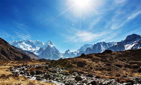
For Everest views and tea-hill mornings, plan for late October to early December or March to April. Monsoon months are greener, but mountain flights delay more often.
Eastern Development Region | Capital: Biratnagar
Home to Mount Everest and Diverse Ethnic Cultures
A short visual overview before you explore geography, districts, and culture.
25,905 km² (10,002 sq mi), borders Tibet to the north and India to the east/south. Contains three geographical regions: Himalayan (19.72%), Hilly (53.18%), and Terai (27.1%).
Ranges from 70m elevation in Terai to 8,848m at Mt. Everest. Contains major rivers: Koshi, Tamor, Arun, and Saptakoshi.
Varied from alpine in Himalayas (-20°C winter) to subtropical in Terai (40°C summer). Annual rainfall ranges from 1,500mm to 2,500mm.
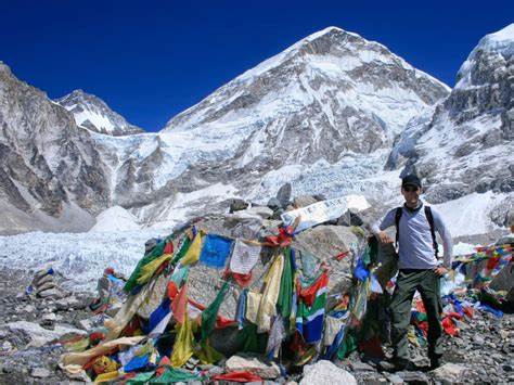
Home to Mount Everest (8,848m) and Sagarmatha National Park (UNESCO World Heritage Site). Gateway to Everest Base Camp trek.
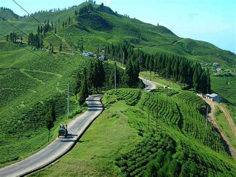
Famous for tea production with beautiful tea gardens. Known as "Queen of Hills" with panoramic Himalayan views.
Agricultural hub producing rice, jute, and tobacco. Contains Nepal's eastern border checkpoint at Kakarbhitta.
Indigenous Kirati people with distinct culture, language (Limbu), and script (Sirijanga). Known for traditional dance forms like Chyabrung and Dhan Naach.
Another Kirati group with diverse sub-groups (Bantawa, Chamling, etc.). Known for their traditional music instruments like dhol, jhyamta, and tungna.
Predominant Hindu groups following traditional caste hierarchy. Mainly engaged in agriculture, government services, and religious activities.
Official language spoken by majority (approx. 44%). Common medium of communication across all districts.
Spoken in southern districts (approx. 18%), especially in Morang, Sunsari, and Jhapa.
Indigenous language with its own script (approx. 8%), primarily in Taplejung, Panchthar, and Ilam.
Main festival of Kirati people celebrating nature and ancestors. Performed twice yearly (Ubhauli in spring, Udhauli in winter).
Limbu harvest festival celebrated with traditional dance (Chyabrung) and special foods like yangben (wild mushroom) and kinema (fermented soybeans).
Major Hindu festivals celebrated by majority population with family gatherings, animal sacrifices, and lights/decorations.
World's highest peak (8,848m) located in Solukhumbu district. Base camp trek (EBC) takes about 12-14 days from Lukla. Sagarmatha National Park (1,148 km²) protects unique Himalayan ecosystem.
Beautiful tea estates producing some of Nepal's finest tea (CTC and Orthodox varieties). Mai Pokhari (lake) and Antu Danda offer panoramic views of Everest and Kanchenjunga at sunrise.
Third highest mountain in the world (8,586m) with diverse flora/fauna. Home to red panda, snow leopard, and over 250 bird species. Trekking routes less crowded than Everest region.
For Everest views and tea-hill mornings, plan for late October to early December or March to April. Monsoon months are greener, but mountain flights delay more often.
Use Biratnagar as your lowland hub, Bhadrapur for Ilam access, and Lukla flights for high Himalayan routes. Keep one flexible buffer day for weather changes.
Carry layered clothing: valley heat and alpine cold can happen in one itinerary. Offline maps, small cash notes, and flight-change options are genuinely useful here.
Major crops: Rice (Jhapa/Morang), maize, wheat, tea (Ilam), cardamom (Taplejung), ginger. Jhapa and Morang are the rice bowls of Nepal with 3 crops/year in some areas.
Biratnagar industrial area with jute mills, sugar factories, and other manufacturing. Dharan is educational/healthcare hub. Major hydro projects: Upper Tamakoshi (456 MW), Arun III (900 MW).
Mountaineering (Everest), trekking (Kanchenjunga, Makalu), tea tourism (Ilam), and religious tourism (Pathibhara Temple). Generates significant foreign income and employment.